
Of the themes that emerged from the #WeLovePrestwood survey, held in Spring 2026, the desire for Prestwood’s environment to be protected and improved is one of the strongest.
Responding to residents’ wishes, PCA will continue to inform on planning issues and comment where Prestwood is affected.
Do you have a strong interest or professional background in planning and/or the environment, and if so, would you like to help PCA? Please drop us a line on info@prestwoodcommunity.uk
Closing date for the consultation on the Buckinghamshire Local Plan is 11.59pm on Sunday 6th September. This is the final opportunity for residents to have a say before the Plan is sent to the planning inspectorate for independent examination.
Follow this link for all that you need to add your comments to the Local Plan consultation.
Can my comments change anything at this late hour?
The requirement to identify the potential for 91,000 homes by 2045 has been a real challenge for a county, of which 32% lies within the Metropolitan Geen Belt, and 27% within the Chilterns National Landscape.
Preparation of the Local Plan has gone through numerous stages over an extended period of time. The final ‘publication’ version represents what Buckinghamshire Council sees as its best efforts to cope with Government’s top-down numerical directive, showing it can meet housing needs for all different groups, providing infrastructure, transport, services, community facilities, whilst protecting against inappropriate development.
Realistically, a comment at this late stage will not change the substance of the proposed Plan, but there would be no harm in reinforcing opinions about the Plan, and the various policies relating to its execution.
As with our previous articles, this post focuses on the impact of the Local Plan within the immediate context of Prestwood.
How is Prestwood affected by the Local Plan?
Cutting to the most important point, paragraph 5.21 of the draft Plan states: “The spatial strategy meets the housing requirements without the need to allocate in the Green Belt, whilst only limited development is located within the Chilterns National Landscape.”
Because Prestwood sits within the Chilterns National Landscape, with considerable area of Green Belt, we are not looking at huge parts of surrounding countryside being earmarked for major housing developments. There is one brownfield site, adjacent to Hazell Road. Allocations over the period of the plan for Prestwood are shown as 15, and 10 for Great Missenden.
In a sense, Prestwood is too small, and the constraints of Green Belt and National Landscape too much of a factor, to be part of the maths required for the Council to satisfy the immediate demands of national government.
Another ‘positive’ is that an up-to-date Local Plan will give much more robust direction on what is and is not permissible in sensitive locations.
Following changes to policy in relation to Green Belt under the new National Planning Policy Framework (NPPF), the most recent planning application on Greenlands Lane was a harbinger of what is to come. Three previous applications had been rejected, including at appeal. Now the developers, through their King’s Counsel, argue that the site should now be considered appropriate for development. Their arguments revolve around definitions of ‘Grey Belt’, ‘Previously Developed Land’, how much this specific site, in a micro context, contributes to the purposes of the National Landscape, and the lack of a sufficient supply of future identified housing supply in Buckinghamshire. The appeal has been heard and the verdict of the Planning Inspectorate’s examiner is awaited. Around the county there is any number of examples of developers putting forward proposals, encouraged by the policy changes.
In our local context, development around Prestwood should not be regarded as being automatically harmful. There are locations around the village where we can expect to see development proposals. These will be evaluated through the planning process, in the normal way, but with an updated framework. Appropriate schemes can add to a vibrant village.
In the event that any significant new development on the edge of the village is brought forward, it must balance the needs of residents and potential residents. It MUST be accompanied by investment in appropriate services, facilities and local transport; and to the extent possible, development must be consistent with current protections on National Landscape and Green Belt. This is pretty much spelt out in policy HO10 “Windfall policy”.
So where IS the Plan proposing to build all these homes?
The local plan document runs to 450 pages, leaving aside the various appendices and supporting documents! So for comprehensive information, we point readers to the source material via the link above.
The strategic approach taken by the Local Plan demonstrates how volume might be achieved:
- Approach 1: Brownfield sites within existing towns and villages.
- Approach 2: Growth on the edges of existing main towns.
- Approach 3: New towns.
- Approach 4: Development at Transport Hubs.
- Approach 5: Expansion near key employment hubs.
- Approach 6: Limited expansion of villages.
- Approach 7: Expanding urban area on the edge of Buckinghamshire.
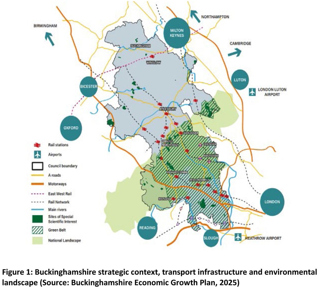
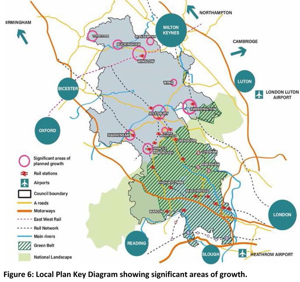
In broad terms, the bulk of the housing sites are in the northern half of the county, away from the constraints of Green Belt and Chiltern National Landscape. Nearly 27,000 homes are expected to be built in ‘New and Expanded Settlement Study’ (NESS) sites. The closest of these to Prestwood are at Princes Risborough (2,895 houses, hard up against the boundary of the Chilterns National Landscape) and Stoke Mandeville (1,650, very close to the edge of Chilterns National Landscape and adding to significant recent building developments).
As recently as last month, an update to the NPPF introduced a “default yes” planning approach to fast-track housing developments within walking distance of well-connected transport hubs across England.
In the towns close to Prestwood, the Plan details regeneration strategies, brownfield development and employment sites in Aylesbury, High Wycombe and Chesham, with public realm and local transport improvements.
Also in our vicinity, various sites around High Wycombe, Hazlemere and Wendover (RAF Halton) are identified.
What would happen if Buckinghamshire Local Plan is not passed by Planning Inspectorate?
Adjoining Three Rivers District Council has experienced the Government intervention that can happen in such circumstances. With 76% of its area designated as Green Belt, its original Plan could not satisfy central Government demand, and having issued a ‘holding direction’, the Government has imposed additional green belt sites.